
")

The Earthquake information and Tsunami warning - Institute of Earth Sciences (IES) earthquake report
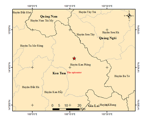
An earthquake occurred at 11:27:46 Hanoi Time (GMT+7) on Monday, May 12, 2025, with a magnitute of 3.0 local depth about 8.1 km. The epicenter was located (14.8110N, 108.2790E) in Kon Plong district, Kon Tum province. The level of disaster risk is 0.
Vietnam Earthquake information and Tsunami warning center, Institute of Earth Sciences will continue monitoring this Earthquake.
FOCUS OF EARTHQUAKE MAP
Hanoi, May 12 2024.
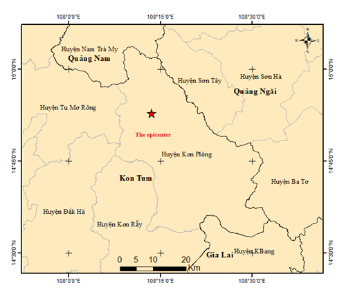
The Earthquake information and Tsunami warning - Institute of Earth Sciences (IES) earthquake report
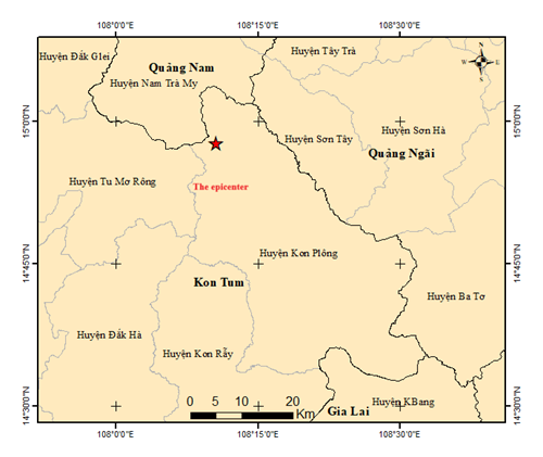
An earthquake occurred at 21:55:08 Hanoi Time (GMT+7) on Saturday, May 02, 2025, with a magnitute of 3.3 local depth about 8.1 km. The epicenter was located (14.9610N, 108.1760E) in Kon Plong district, Kon Tum province. The level of disaster risk is 0.
Vietnam Earthquake information and Tsunami warning center, Institute of Earth Sciences will continue monitoring this Earthquake.
FOCUS OF EARTHQUAKE MAP
Hanoi, May 02 2024.
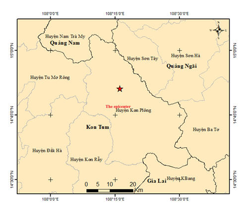
The Earthquake information and Tsunami warning - Institute of Earth Sciences (IES) earthquake report
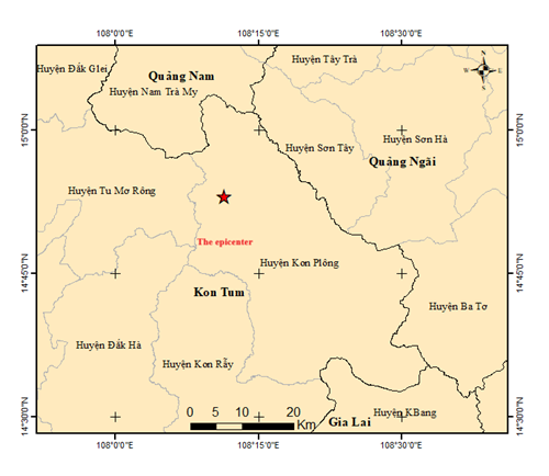
An earthquake occurred at 21:12:32 Hanoi Time (GMT+7) on Saturday, May 02, 2025, with a magnitute of 2.9 local depth about 8.3 km. The epicenter was located (14.8840N, 108.1900E) in Kon Plong district, Kon Tum province. The level of disaster risk is 0.
Vietnam Earthquake information and Tsunami warning center, Institute of Earth Sciences will continue monitoring this Earthquake.
FOCUS OF EARTHQUAKE MAP
Hanoi, May 02 2024.
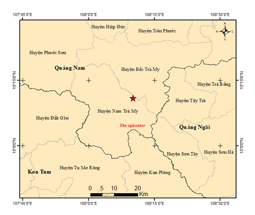
The Earthquake information and Tsunami warning - Institute of Earth Sciences (IES) earthquake report
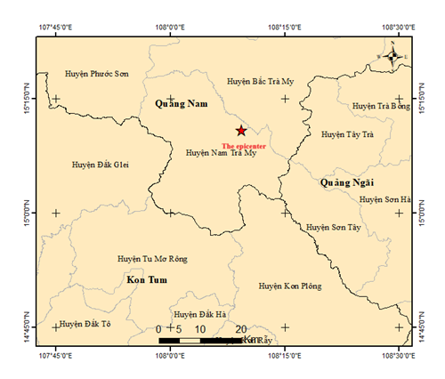
An earthquake occurred at 19:20:16 Hanoi Time (GMT+7) on Thursday, May 01, 2025, with a magnitute of 3.8 local depth about 8.1 km. The epicenter was located (15.1810N, 108.1550E) in Nam Tra My district, Quang Nam province. The level of disaster risk is 0.
Vietnam Earthquake information and Tsunami warning center, Institute of Earth Sciences will continue monitoring this Earthquake.
FOCUS OF EARTHQUAKE MAP
Hanoi, May 01 2024.
The Earthquake information and Tsunami warning - Institute of Earth Sciences (IES) earthquake report
An earthquake occurred at 17:20:16 Hanoi Time (GMT+7) on Thursday, May 01, 2025, with a magnitute of 2.7 local depth about 8.1 km. The epicenter was located (15.1090N, 108.0890E) in Nam Tra My district, Quang Nam province. The level of disaster risk is 0.
Vietnam Earthquake information and Tsunami warning center, Institute of Earth Sciences will continue monitoring this Earthquake.
FOCUS OF EARTHQUAKE MAP

Hanoi, May 01 2024.
The Earthquake information and Tsunami warning - Institute of Earth Sciences (IES) earthquake report
An earthquake occurred at 14:02:26 Hanoi Time (GMT+7) on Thursday, May 01, 2025, with a magnitute of 2.6 local depth about 8.1 km. The epicenter was located (15.1810N, 108.1680E) in Nam Tra My district, Quang Nam province. The level of disaster risk is 0.
Vietnam Earthquake information and Tsunami warning center, Institute of Earth Sciences will continue monitoring this Earthquake.
FOCUS OF EARTHQUAKE MAP
Hanoi, May 01 2024.
The Earthquake information and Tsunami warning - Institute of Earth Sciences (IES) earthquake report
An earthquake occurred at 04:19:13 Hanoi Time (GMT+7) on Wednesday, April 30, 2025, with a magnitute of 2.8 local depth about 8.1 km. The epicenter was located (14.8520N, 108.2680E) in Kon Plong district, Kon Tum province. The level of disaster risk is 0.
Vietnam Earthquake information and Tsunami warning center, Institute of Earth Sciences will continue monitoring this Earthquake.
FOCUS OF EARTHQUAKE MAP
Hanoi, Arpil 302024.
The Earthquake information and Tsunami warning - Institute of Earth Sciences (IES) earthquake report
An earthquake occurred at 04:19:13 Hanoi Time (GMT+7) on Tuesday, April 29, 2025, with a magnitute of 2.8 local depth about 8.1 km. The epicenter was located (14.8800N, 108.2260E) in Kon Plong district, Kon Tum province. The level of disaster risk is 0.
Vietnam Earthquake information and Tsunami warning center, Institute of Earth Sciences will continue monitoring this Earthquake.
FOCUS OF EARTHQUAKE MAP
Hanoi, Arpil 29 2024.